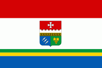
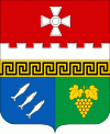
Balaklava Raion (Balaklava District)
 |
 |
The raion was created in 1930 as part of the Crimean ASSR with its administrative center in Balaklava. After World War II in 1957, it became part of Sevastopol city municipality. All populated places of the raion became incorporated with the city of Sevastopol. In 1976, the city of Inkerman was reinstated as a city. Population:
The raion is subdivided into three municipality (councils): Inkerman city council, Orlyne rural council, and Ternivka rural council. Balaklava District borders with Bakhchysarai Raion and Yalta Municipality.
* Baydar Valley
Map - Balaklava Raion (Balaklava District)
Map


Country - Ukraine
 |
 |
| Flag of Ukraine | |
During the Middle Ages, Ukraine was the site of early Slavic expansion and the area later became a key centre of East Slavic culture under the state of Kievan Rus', which emerged in the 9th century. The state eventually disintegrated into rival regional powers and was ultimately destroyed by the Mongol invasions of the 13th century. The area was then contested, divided, and ruled by a variety of external powers for the next 600 years, including the Polish–Lithuanian Commonwealth, the Austrian Empire, the Ottoman Empire, and the Tsardom of Russia. The Cossack Hetmanate emerged in central Ukraine in the 17th century, but was partitioned between Russia and Poland, and ultimately absorbed by the Russian Empire. Ukrainian nationalism developed, and following the Russian Revolution in 1917, the short-lived Ukrainian People's Republic was formed. The Bolsheviks consolidated control over much of the former empire and established the Ukrainian Soviet Socialist Republic, which became a constituent republic of the Soviet Union when it was formed in 1922. In the early 1930s, millions of Ukrainians died in the Holodomor, a man-made famine. During World War II, Ukraine was devastated by the German occupation.
Currency / Language
| ISO | Currency | Symbol | Significant figures |
|---|---|---|---|
| UAH | Ukrainian hryvnia | â‚´ | 2 |
| ISO | Language |
|---|---|
| HU | Hungarian language |
| PL | Polish language |
| RU | Russian language |
| UK | Ukrainian language |